Sebaldusweg stage 2 | Laussa - Maria Neustift
средний
Паломнический маршрут 4,2
Перейдите по ссылке .
Получите этот тур на свой мобильный телефон
Карта
Sebaldusweg stage 2 | Laussa - Maria Neustift
средний
Паломнический маршрут
20,89 км
Отсканируйте QR-код и запустите навигацию в приложении bergfex.
QR Code
Походы и трекинг
Походы и трекинг

Sebaldusweg stage 2 | Laussa - Maria Neustift

средний
Паломнический маршрут 4,2
Расстояние
20,89 км
Продолжительность
06:45 h
Подъем
935 hm
Уровень моря
433 - 990 m
Скачать трек
Карта
Sebaldusweg stage 2 | Laussa - Maria Neustift
средний
Паломнический маршрут
20,89 км

Фотографии наших пользователей

Discover along the way:
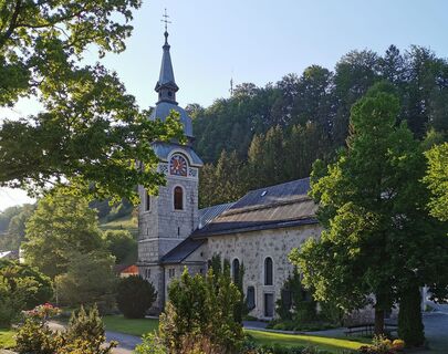
Parish church in Laussa (consecrated to St. Mary), limestone wall nature reserve and open-air swimming pool in Laussa, several chapels, stations of the Motorikpark Laussa, pilgrimage...


Описание
Discover along the way:

Parish church in Laussa (consecrated to St. Mary), limestone wall nature reserve and open-air swimming pool in Laussa, several chapels, stations of the Motorikpark Laussa, pilgrimage church Maria Neustift (Maria Heil der Kranken), salvation path as well as signposted chapel paths with a magnificent panorama in Maria Neustift, traditional wood-fired oven pastries.

Off the beaten track:
Laussa Orchideenwiese nature reserve, sport climbing with over 180 routes on several rocks situated in and around the village centre, including the famous "Sauzahn", THE climbing centre in the Enns Valley. Maria Neustift family-friendly hikes on the Glasenberg and Freithofberg, Ramingtaler Bogenparcours. 

Breathe deeply:
Plattenberg - wind turbines Enjoy the view on the entire ridge of the Sonnberg.

Маршрут
Kirche Laussa
(432 m)
Место поклонения
0,0 км
Friedenskapelle
(756 m)
Место поклонения
4,3 км
Sonnberg
(777 m)
Саммит
4,6 км
Willeitenberg
(837 m)
Саммит
6,1 км
Spadenberg
(1 000 m)
Саммит
12,7 км
Kirche Maria Neustift
(612 m)
Место поклонения
20,8 км
Gasthaus Schaupp
(609 m)
Ресторан
20,9 км
Маршрут
Карта
Sebaldusweg stage 2 | Laussa - Maria Neustift
средний
Паломнический маршрут
20,89 км
Laussa
(432 m)
Деревня
0,0 км
Kirche Laussa
(432 m)
Место поклонения
0,0 км
Gasthaus zum Geiger
(443 m)
Ресторан
0,1 км
Friedenskapelle
(756 m)
Место поклонения
4,3 км
Sonnberg
(773 m)
Точка зрения
4,5 км
Sonnberg
(777 m)
Саммит
4,6 км
Willeitenberg
(837 m)
Саммит
6,1 км
Spadenberg
(1 000 m)
Саммит
12,7 км
Geierkogel
(886 m)
Саммит
15,4 км
Glasnerhütte
(789 m)
Приют
17,7 км
Kirche Maria Neustift
(612 m)
Место поклонения
20,8 км
Maria Neustift
(612 m)
Деревня
20,8 км
Gasthaus Schaupp
(609 m)
Ресторан
20,9 км
Описание
Starting point: Laussa

Stage destination: Maria Neustift

Route conditions: Hiking trail, asphalt, forest road

Trail length: 22 km

Altitude difference: approx. 950 m

Laussa village square - Sonnberg - long-distance trail 04/06 - Windpark - Spadenberg - Glasenberg - Maria Neustift; alternative: from the Kleinschönleiten inn to Sonnberg

Технология
3 / 6
Состояние
3 / 6
Ландшафт
5 / 6
Опыт
5 / 6
Лучшее время года
янв
фев
мар
апр
май
июн
июл
авг
сен
окт
ноя
дек
Автор
Предоставлено Tourismusverband Steyr Nationalpark Region
Тур Sebaldusweg stage 2 | Laussa - Maria Neustift предоставляется сайтом outdooractive.com.
Logo
Акция тура
Карта
Sebaldusweg stage 2 | Laussa - Maria Neustift
средний
Паломнический маршрут
20,89 км
Ошибка
Произошла ошибка. Пожалуйста, попробуйте еще раз.
Информация о маршруте
Маршрут

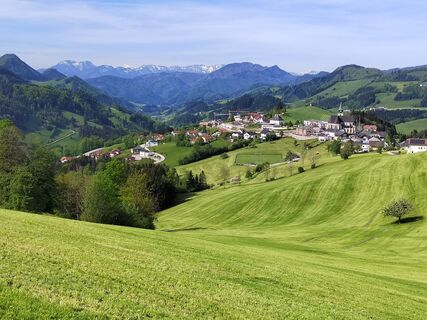
From the Laussa parish church, walk to the Geiger inn, then behind the inn along the climbing rock and up via a meadow path. At the Breitn Chapel, turn left onto the Rotbauer Güterweg (goods path), along the Flößerweg (raftsmen's path), and after a long stretch uphill, past the Schneiderweg holiday farm, you reach the turnoff onto the ridge of the Sonnberg. From here you follow the long-distance hiking trail 04/06, pass the Laussa wind farm, then the Spadenberg and arrive at Maria Neustift via the Glasenberg - a detour to the summit is very worthwhile because of the view and the panorama of pre-Alpine peaks.


Alternative from Gasthof Kleinschönleiten: from the inn, hike along the Kneipp Peace Trail (E 50) across the juniper heath to the Rebenstein Wall natural monument and from there continue in the direction of Sonnberg, where you meet up with the Sebaldus Trail again.

Оборудование

Sturdy walking shoes, sun and rain protection, first aid kit for emergencies, possibly walking sticks.

Указания по технике безопасности

As there are few opportunities to stop for refreshments directly along the trail, it is advisable to take enough snacks and drinks with you.

Информация о прибытии
Прибытие
Arrival by car:From Salzburg/Linz:

A1 motorway exit Enns-Steyr > B115 into the Enns Valley. From Vienna: A1 motorway exit Haag > B42 > B122 > B115 into the Enns Valley From Passau: A8 Passau > Wels > A1 motorway exit Enns-Steyr > B115 into the Enns Valley From Graz: A9 Pyhrnautobahn > motorway exit Klaus > Grünburg > into the Ennstal valley

Общественный транспорт

The Ennstalbahn runs between Linz and Weißenbach-St. Gallen. Details at www.ooevv.at

Railway Stations are located in Steyr, Garsten, Lahrndorf, Dürnbach, Ternberg, Trattenbach, Losenstein, Reichraming, Großraming, Gaflenz, Weyer, Küpfern, Kastenreith, Kleinreifling and Weißenbach-St. Gallen.

Парковка
Public parking facilities


Großraming: Public parking spaces behind the Landesmusikschule or at the former Salzwimmer Inn.

Losenstein: Public parking spaces at the railway station or at the Blasl family inn.

Laussa: Öffentliche Parkplätze (public parking spaces) opposite Kaufhaus Baumgartner.

Maria Neustift: Öffentliche Parkplätze (public parking spaces) on the left behind the Gemeindeamt (municipal office).

Gaflenz: Public parking spaces at the municipal office, open-air swimming pool

Weyer: Kreuzberg car park

Дополнительная информация и советы
Дополнительная информация

Information on places to stop for refreshments and overnight stays or bookable offers at www.sebaldusweg.at

Советы
Stop off on the way:

Maria Neustift Glasner Hütte, Roisentaverne, GasthausBäckerei Schaupp, BäckereiCafe Steinparzer

Оценки
4,2
5
(6)
4
(1)
3
(1)
2
(0)
1
(1)
4 Комментарии
Аватар из Hans Schwertberger
Hans Schwertberger
07. мая. 2025
Проверено
Seebaldusweg 2
Полезное (0) |
Отчет
Ошибка
Произошла ошибка. Пожалуйста, попробуйте еще раз.
Аватар из Martina Nimmervoll-dorfer
Martina Nimmervoll-dorfer
20. авг. 2024
sebaldusweg 2
Аватар из Christine
Christine
14. июн. 2024
Wunderschöne Tour, wenn man Durst hat dauert es nicht lange, dass eine Getränkestation auftaucht. Gemütliche Liegen und Sitzbänke säumen den Weg. Bei einer Rast auf der Hängematte bei den Windrädern fühlt man sich dem Himmel ganz nah.
Оценки
Карта
Sebaldusweg stage 2 | Laussa - Maria Neustift
средний
Паломнический маршрут
20,89 км
4,2
5
(6)
4
(1)
3
(1)
2
(0)
1
(1)
4 Комментарии
Аватар из Hans Schwertberger
Hans Schwertberger
07. мая. 2025
Проверено
Seebaldusweg 2
Аватар из Martina Nimmervoll-dorfer
Martina Nimmervoll-dorfer
20. авг. 2024
sebaldusweg 2
Аватар из Christine
Christine
14. июн. 2024
Wunderschöne Tour, wenn man Durst hat dauert es nicht lange, dass eine Getränkestation auftaucht. Gemütliche Liegen und Sitzbänke säumen den Weg. Bei einer Rast auf der Hängematte bei den Windrädern fühlt man sich dem Himmel ganz nah.
Аватар из Sebastian gfrerer
Sebastian gfrerer
07. мар. 2024
Sebalduswe etappe 2
Написать отзыв

Отзывы помогают другим пользователям выбрать следующее приключение. Пожалуйста, оценивайте только тур, а не погоду или ваш перекус.

Выберите одну из звезд, чтобы оценить тур
Плохой тур
Слабый тур
Посредственный тур
Хороший тур
Отличный тур
bergfex logo Узнайте больше Всегда в прямом эфире с более чем 9500 веб-камер. bergfex Как пользователь Pro, вы теперь можете видеть соответствующие веб-камеры для многих туров в приложении Туры из. Это позволяет просматривать текущие условия напрямую.
Походы и трекинг

Походы и трекинг

Походы и трекинг
Более 550.000 предложений по экскурсиям, подробные карты и интуитивно понятный планировщик маршрутов делают это приложение обязательным для всех любителей природы.
Походы и трекинг