Aprica to Venerocolo Pass
тяжелый
Горный велосипед
Перейдите по ссылке .
Получите этот тур на свой мобильный телефон
Карта
Aprica to Venerocolo Pass
тяжелый
Горный велосипед
34,90 км
Отсканируйте QR-код и запустите навигацию в приложении bergfex.
QR Code
Походы и трекинг
Походы и трекинг

Aprica to Venerocolo Pass

тяжелый
Горный велосипед
Расстояние
34,90 км
Продолжительность
06:28 h
Подъем
1 434 hm
Уровень моря
918 - 2 322 m
Скачать трек
Карта
Aprica to Venerocolo Pass
тяжелый
Горный велосипед
34,90 км

You start from the car park nearby Magnolta ski runs and take the dirt road climbing up to the left of the cableway. The sign indicates Malga Magnolta and Passo Venerocolo. You can easily cycle on the...


Описание

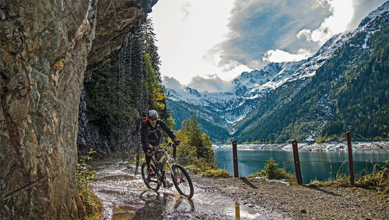
You start from the car park nearby Magnolta ski runs and take the dirt road climbing up to the left of the cableway. The sign indicates Malga Magnolta and Passo Venerocolo. You can easily cycle on the first half of the uphill dirt road, which then gets much steeper from the mountain huts in Corna Alta 1457 m to the finish of the cableway 1870 m, so that you may need to carry your MTB. This is a challenging ascent but in summertime you can use the lift up to Magnolta. Halfway up the second ski lift, at 1940 meters, the track becomes a flat trail, which goes into the wood, turns south and enters Val Belviso. You have to ride for about 13 km on a flat path going sometimes gently uphill, going past Malga Magnola 1997 m and crossing the Valle del Latte and the Valle di Pisa. You have to pay attention to some exposed stretches. The first part of the descent from Passo di Venerocolo 2314 m to the dirt road at 2000 meters above Malga di Campo 1816 m is steep and not very flowing. The downhill ride alongside the artificial lake and through the remaining part of Val Belviso does not hinder your fun. The route ends with the ascent on a paved road from Ponte Ganda 906 m to the resort town of Aprica.
Маршрут
Malga Magnola
(1 998 m)
Коридор/рельеф
6,6 км
Malga di Campo
(1 822 m)
Коридор/рельеф
20,6 км
Rifugio Cristina
(1 279 m)
Приют
27,8 км
Liscedo
(941 m)
Поселение
32,7 км
Liscidini
(1 056 m)
Соседство
33,4 км
Santa Maria
(1 093 m)
Соседство
33,8 км
Chiesa di Santa Maria
(1 112 m)
Место поклонения
34,1 км
Маршрут
Карта
Aprica to Venerocolo Pass
тяжелый
Горный велосипед
34,90 км
Aprica
(1 214 m)
Гондольная станция
0,0 км
Malga Magnola
(1 998 m)
Коридор/рельеф
6,6 км
Malga di Campo
(1 822 m)
Коридор/рельеф
20,6 км
Ponte Frera
(1 389 m)
Коридор/рельеф
26,6 км
Rifugio Cristina
(1 279 m)
Приют
27,8 км
San Paolo
(1 254 m)
Поселение
28,1 км
Ponte Ganda
(912 m)
Коридор/рельеф
31,7 км
Liscedo
(941 m)
Поселение
32,7 км
Liscidini
(1 056 m)
Соседство
33,4 км
Santa Maria
(1 093 m)
Соседство
33,8 км
Chiesa di Santa Maria
(1 112 m)
Место поклонения
34,1 км
Описание

This is the only route of this guide that extends wholly through a val ley belonging to the Orobic Alps. Val Belviso is the last eastern valley, it is long, deep and narrow, but along the path going south from Alpe Magnolta to Passo di Ven erocolo it seems bright and wide. The outline of Monte Torena the last high peak of Oro bic Alps dominates the other side westwards reflecting its shape into the waters of the huge artificial lake on the valley bottom. Once you get to the pass dividing us from the Province of Bergamo, you will find some alpine lakes wedged among the rocks and the grassy small hills. The descent runs on a trail at first and then turns into a dirt road through the whole valley, both alongside the lake and under the dam. In San Paolo the Rifugio Cristina is a nice place to grab calories and shelter.

Технология
н.д.
Состояние
6 / 6
Ландшафт
4 / 6
Опыт
3 / 6
Лучшее время года
янв
фев
мар
апр
май
июн
июл
авг
сен
окт
ноя
дек
Автор
Предоставлено Valtellina Outdoor
Тур Aprica to Venerocolo Pass предоставляется сайтом outdooractive.com.
Logo
Акция тура
Карта
Aprica to Venerocolo Pass
тяжелый
Горный велосипед
34,90 км
Ошибка
Произошла ошибка. Пожалуйста, попробуйте еще раз.
Последний отслеженный неделю назад
Информация о маршруте
Маршрут

Aprica, Magnolta lifts parking lot - Corna Alta - Magnolta - Malga Magnolta - Val Belviso - Malga Magnolta - Venerocolo Pass - Malga di Campo - Lake Belviso - San Paolo - Ponte Ganda - Aprica

Информация о прибытии
Парковка

Magnolta Facilities

Отзывов пока нет
Написать отзыв

Отзывы помогают другим пользователям выбрать следующее приключение. Пожалуйста, оценивайте только тур, а не погоду или ваш перекус.

Выберите одну из звезд, чтобы оценить тур
Плохой тур
Слабый тур
Посредственный тур
Хороший тур
Отличный тур
bergfex logo Узнайте больше Всегда в прямом эфире с более чем 9500 веб-камер. bergfex Как пользователь Pro, вы теперь можете видеть соответствующие веб-камеры для многих туров в приложении Туры из. Это позволяет просматривать текущие условия напрямую.
Походы и трекинг

Походы и трекинг

Походы и трекинг
Более 550.000 предложений по экскурсиям, подробные карты и интуитивно понятный планировщик маршрутов делают это приложение обязательным для всех любителей природы.
Походы и трекинг

Не пропустите предложения и вдохновение для вашего следующего отпуска

Подписаться на рассылку
Ошибка
Произошла ошибка. Пожалуйста, попробуйте еще раз.
Спасибо за регистрацию

Ваш адрес электронной почты был добавлен в список рассылки.