- Краткое описание
-
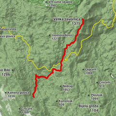
The most interesting phenomenon in this route stage is the group of rocks called Kolovratske stijene, offering a wonderful view towards the sea. The rocks of Kolovratske stijene extend south of the group of Samarske stijene and Bijele stijene, as a solitary ridge on the very edge of Velika Kapela, where the mountain's slopes begin descending towards the sea. The rocky peak area of the ridge of Kolovratske stijene is approximately one kilometer long. Among hikers, Kolovratske stijene are not so well known, since the rocks of Bijele stijene and Samarske stijene are much better known, taller and more beautiful. However, the charm of Kolovratske stijene lies precisely in the fact that they are solitary and close to the sea.
- Трудность
-
средний
- Оценка
-
- Маршрут
-
Gorica (1.026 m)11,8 kmAlino bilo (1.106 m)13,7 kmKrivi Put16,0 kmNikolići16,7 kmGornji Veljun19,4 kmVeljun Primorski20,1 km
- Самая высокая точка
- 1.084 m
- Место назначения
-
Vratnik
- Профиль возвышения
-
 © outdooractive.com


-

-
АвторТур Via Dinarica HR-W-08 Connecting trail Kapela - Velebit используется outdooractive.com предоставлен.
GPS Downloads


Другие туры в регионах
-
Crikvenica
35
-
Senj
7