© Geopark Karnische Alpen - F-Messner

© Geopark Karnische Alpen - Nassfeld - Pressegger See

- Краткое описание
-
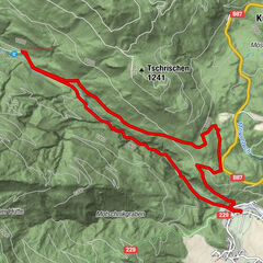
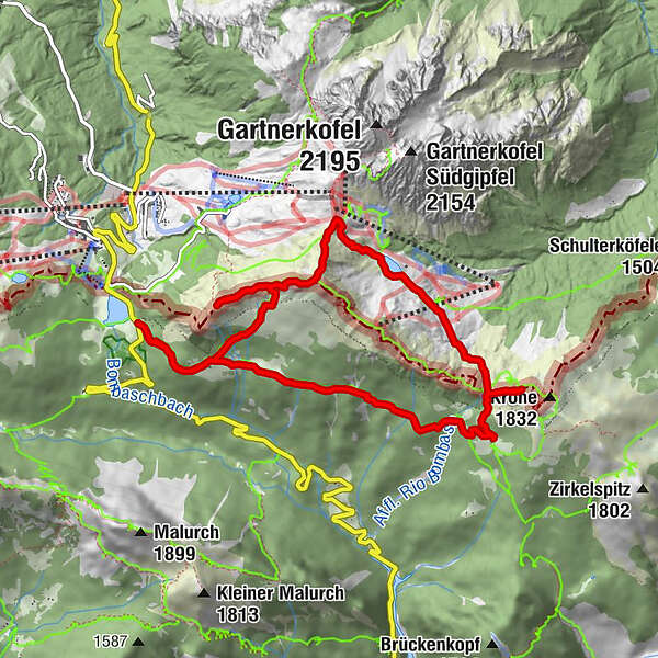
The geotrail starts near the little lake of Pramollo: you can reach the Pass of the same name with your own transportation, arriving from Pontebba (Italian side), or from Hermagor (Austrian side). Both routes take about 40 minutes starting from the valley bottom. The geotrail begins right at the back of the Al Gallo Forcello Hotel, where you take the mule track that leads to Casera Auernig.
It is advisable, given the length of the geotrail, to pay attention to the rapid weather changes typical of high altitude, and be equipped with clothing suitable for sudden rains and low temperatures even in summer.
- Трудность
-
несложный
- Оценка
-
- Маршрут
-
Albergo Ristorante Wulfenia da LivioPasso Pramollo0,0 kmAuernil Quelle1,4 kmKronalm3,6 kmGugga (1.928 m)7,3 kmAuernig Sattel (1.818 m)8,0 kmAuernig (1.864 m)8,5 kmAlbergo Ristorante Wulfenia da Livio10,7 km
- Лучший сезон
-
янвфевмарапрмаяиюниюлавгсеноктноядек
- Самая высокая точка
- 1.936 m
- Место назначения
-
Nassfeld Pass (Wulfenia da Livio)
- Профиль возвышения
-
 © outdooractive.com
- Автор
-
Тур Geotrail Passo Pramollo - Nassfeld используется outdooractive.com предоставлен.
GPS Downloads


Другие туры в регионах